After a major hard drive crash and I was finally able to finish editing my images from the trip. You can find them on The Dakotas page of my portfolio.
|
We are HOME!!!!!. We left the lost motel at 8:10. We added another state to our list because this time we went through Cincinnati. So all total: Tennessee, Kentucky, Ohio, Indiana, Illinois, Minnesota, North Dakota, South Dakota, and Wyoming. Today was the hardest day of driving of the whole trip. There was lots of traffic and lots of construction delays, especially in Kentucky. We got gas for the last time on the trip about lunch time. We ate at McAlisters in Richmond, Kentucky - the some one where we ate on the first day of the trip. We got back in Jefferson City and got Weigels skim milk - something we really missed. We unpacked the car and made it to church for prayer meeting. We have unpacked the food and our clothes. We will have a lot to do tomorrow but it will be great to sleep in our own bed and know how the shower works. I will have lots of picture editing to do and it will probably take several weeks before I have final products to share. I will post a link here when I finish.
Miles Today: 388.2 TOTAL MILES FOR THE TRIP: 5,846.0 We left the hotel by 8:00. Our first stop was the Illinois Welcome Center Rest Stop with a view of the Mississippi River that we had just crossed. Traffic was heavy at times and light at others. We had lunch at a ChicFilA in Bloomington, Illinois, the first one we had seen in a long time. It was almost like being at home - they are always so nice and treat you with such respect. We got gas after we crossed into Indiana. We hit Indianapolis right at rush hour since we moved to Eastern Standard Time. We checked into our last hotel! YEAH!!!! Now for the nightly chores and soup for supper. Only one more day of driving, Miles Today: 396.8 Total So Far: 5457.8  Mississippi River We got an early start this morning and were on the road by 7:30. We got gas south of Sioux City, Iowa. The skies were cloudy but no rain and there was little traffic on this part of the road so we made good time. There are not a lot of cities large enough for a restaurant on highway 20, a nice divided highway, so there weren't many choices for lunch or places to picnic. We decided to stop in Webster City and just get a snack to hold us over to Cedar Rapids. We stopped at at '"Kwik Stop" that had a soup bar so we got a small Mac and cheese and I got tomato juice and Thomas got milk. These are things that we have missed on the trip since they are hard to find in small sizes. The rain started about an hour from Cedar Rapids and we got here around 2:30. We found a Panera and also got orange scones for a treat for later. We checked into the hotel and rested for a short time. Since there was no nature trail or park and it was raining we decided to go to the Walmart and walk.This was the biggest. Walmart I have ever seen. We got gas for tomorrow since it was $.10 per gallon cheaper here. Back to the room for our treat and nightly chores, though much abbreviated since I didn't take any pictures today. One day of driving down, 2 to go. Miles To Day: 352.7 and we hit a milestone for total miles: 5060.9
Since the day was cloudy, windy, and cold we decided to take our time getting ready. We left the motel about 9:00. We got gas and headed out on the Native American Scenic Byway which consists of highways 50, 44, and 30. Actually the the first 15 miles were on I-90 because of road closure on 50. The drive was mostly on plains and prairies. Our first stop was Lake Francis Chase created by Fort Randal Dam. There was a Wayside Chapel right at the Platte Bridge. It was so windy that it was hard to stand up. I kind of felt like Jim Cantori of the Weather Chanel reporting on a hurricane without rain. The next stop was the Randal Creek Recreation Area. The skies had cleared by now but the wind was still very strong. Luckily we found a picnic shelter with a wall and we were able to eat without too much wind. After lunch we walked the Fort Randal Historic site. All that was left from the fort was the remains of a stone church. Close by was the Karl E. Mundt National Wildlife Refuge which was really a field with no trails. So we drove back down the 2 mile gravel road - boy have we driven down a lot of these! We headed to the Lewis and Clark Resort which is part of the Lewis and Clark Recreation Area. It is on the Lewis and Clark Lake which is created by the Gavins Point Dam. We checked into our lodge room and walked a short way on the paved bike trail. We drove to the Visitor's Center of the park and then did the Nature Trail - which like so many other trails did not have a good map or trail blazes. We ended up having to back track to keep from getting lost. We drove back to the dam. There are a lot of dams on the Missouri River - so many we have lost count of how many we have seen. What is different about these Army Corps of Engineers Dam from TVA dams is that you can get very close to them - this one we actually drove over. Once we drove over the dam we were in Nebraska. We had a soup supper in our room and walked on the bike trail to catch the last sunset of our trip. We did the nightly chores and got ready for our long drive home. Miles Today: 193.9 Total So Far: 4708.2  Sunset on Lake Lewis and Clark Lake on the Missouri River We woke up to light rain and clouds and left the hotel around 8:30. We traveled on the Lewis and Clark and Native American Scenic Highway, Highway 1806. This is a very lonely highway. We passed only 3 or 4 cars. We also had about a 30 mile detour when 1806 was closed close to Lower Brule. The Buffalo Interpretive Center and the Sioux Museum were also closed. We had lunch at the famous since 1937, “Al’s Oasis.” It is kind of like a miniature Wall Drug or a large Cracker Barrel. We headed to our hotel at 1:00. They did not have a room ready so we tried a little walk along the river but the rain started again so we headed back to the hotel to just wait in the lobby for our room. We got a room about 2:30 - thankfully it is on the bottom floor so no steps. After resting for a little while we drove to the Dignity Statue. The statue is 50 feet high and portrays a Native American women with a star quilt. When we came this way in 2017 on our road trip to Glacier we stopped at this rest stop for a picnic lunch and had no idea that this statute and a Lewis and Clark Interpretive Center were here. We just thought it was a regular rest stop along I-90. So when I planned this trip I wanted to stay here and see the statue at night when it is lit up. After checking into our room and resting a little we decided to back sure we could find the statute at night so we drove the 15 minutes to the statue. There were stormy skies all around but only a little sprinkle of rain. On the way back to the hotel we stopped at the grocery store for more yogurt since breakfast is not included here. We had yogurt for supper since we had such a big lunch. We planned our route back home and made the reservations for the final two nights of the trip. On Monday we will stay in Cedar Rapids, Iowa and on Tuesday we will stay in Indianapolis, Indiana. We waited until dark and then headed back to the statute. We are under a thunderstorm warning but according to the radar the storms are north of us. We could see cloud to cloud lightening in the sky but we still drove the 1 exit on the interstate to see the statute. We got back to the hotel without getting struck by lightening or rained on. Now to do the daily chores and get ready for tomorrow. This is a nice hotel on a marina on Lake Sharpe on the Missouri River. Lewis and Clark stayed in this area on both the trip west and the trip back east. Miles Today: 152.3. Total So Far: 4519.3  Dignity of Earth and Sky - 50 foot statue of a Native American Woman with a star quilt Today was a travel day so we didn't do our sunrise routine, just our regular get up at 6:00am routine. After getting ready I looked outside and saw some color in the sky so I quickly drove up to Cliff Shelf. I got a few images of the clouds over the prairie. We finished getting ready, had breakfast and started packing up. We stopped at the last overlook before leaving the park at the northeast entrance - the only one we hadn't stopped at. We stopped at the Prairie Homestead Historic Site right outside the park but it was closed for the season. However you could see the sod house and barn from the parking lot. We got on I-90 and headed toward Pierre. We also moved back to Central Standard Time. In Pierre we started with the Cultural History Museum and then the State Capitol. We didn't tour it, just walked the grounds. There is a lake on the grounds fed by an Artesian Spring. The state has made this into a war memorial. We found at picnic table at the Visitor's Center, which was closed and had our salad kit lunch. We then tried to visit the Bird Sanctuary island in the Missouri River - but the road to it was closed. We checked into our motel and found out the guest laundry was next to our room and we needed quarters. We stopped at the closest bank and then headed to the Oahe Dam. The Visitor's Center here was also closed . We headed back to town to get gas and a car wash. Since the car wash was having maintenance issues and wouldn't be available for 30 minutes we decided to stop at the grocery story for laundry detergent. There was a Subway a block down from our hotel so we walked and got a footlong sandwich. We ate I our room and then went back to get the car washed. We did laundry and are other daily chores. So glad we are on the first floor here since there is no elevator. Miles Today: 153.3. Total Miles So Far: 4361.9  South Dakota State Capital and Capital Lake War Memorial What a day! We followed our usual sunrise routine which means getting up 15 minutes before it is time to leave - this varies depending on how far we have to drive to get to the location 45 minutes before sunrise. This morning we were out by 6:00 am for sunrise at 6:59 am. There were clouds this morning and sunrise and golden hour were amazing. We were back at the cabin by 7:30 - we are staying in the park and we only had to drive 6 minutes. Since the sky and clouds were so amazing and clear skies were predicted by afternoon we ate breakfast, got our lunch choices ready and decided to just get on the road without getting ready. We went back and did the Cliff Shelf trail again. We drove on the scenic loop and then on Stage Creek Rim Road to the last lookout. We headed back toward the cabin and stopped at the Conata Basin Picnic Area for lunch. We made many stops since the sky was filled with clouds. We got back to the cabin by 2:30 and got cleaned up and rested some. We also had to refill the ice in the Yeti. We decided not to do any night photography and just do a sunset. The skies were mostly clear by now so we knew we wouldn’t get much color in the sky. We decided on the Cliff Shelf Trail again. We had soup for supper and then headed out at 5:00 for a 6:15 sunset. It was what we expected but still this is a beautiful place. We will leave tomorrow so there is reorganizing and packing for travel and the other nightly chores. Miles Today: 69.4. Total Miles So Far: 4208.5  Golden Hour at the Notch Trailhead We got up early and left quickly to get a sunrise at the Door Trail. Just as we were getting out of the car a tour bus pulled up full of photographers at a photography conference. It was very frustrating but I got some good shots - just had to be a little patient with all the photographers trying to get a good shot. After sunrise we returned to the cabin and had breakfast and got ready for the day. We hiked the Cliff Shell Nature Trail, which was gorgious. I could hardly do the trail for stopping to take pictures. We got there at just the right time for beautiful blue skies. Next stop was the Notch Trail. This trail is easy for the first half but then it gets to a ladder that you have to climb to get up to the top. We knew this was beyond our ability. Additionaly the view from the top was the same as the one from the nature trail but just a little higher. By this time it was close to lunch so we decided that we would have the Indian Fry Bread Taco that the Cedar Pass Restaurant is famous for. It was good but a little spicy for me. After lunch we rested a little to recover from the heavy lunch. We drove on the scenic road to the Stage Creek Rim Road. This gravel road looks out over the grassy buttes. The light will be much better in the early morning before lunch so we will come back and do part of this road tomorrow morning. Since we were close to Wall we decided to go ahead and get gas and groceries there. We headed back on the scenic drive to the cabin to have a light supper - since lunch was so heavy- and wait for dark. There are no clouds so a sunset would not be any different from the one last night. We went out for another try at Milky Way photography - maybe a little improved this time. Miles Today: 96.4. Miles So Far: 4139.1  The Door Trail, Badlands National Park We left Custer State Park today. We got a breakfast sandwich when passing through the western edge of Rapid City. We got gas in Interior, South Dakota, the town closest to the southern entrance to Badlands National Park. We arrived in the park to 10:30 and since the room wasn't going to be ready until the afternoon we stopped at the Visitor's Center and then drove on the scenic loop to the Pinnacles Overlook. We had our picnic lunch along the way. We headed back to Cedar Pass Lodge and checked into our cabin at 2:30. The cabin is much better than the one at Custer. We have wifi again so I updated the journal entries that I couldn't upload in Custer. We drove on the scenic drive north to the Door and Notch overlooks to scout a place for sunset and night photography. We came back to the cabin for supper - it is only about a 10 minute or less drive. After out soup supper we drove back to the Door/Notch parking area and did sunset photos. We waited an hour until the Milky Way rose in the night sky. I still have a lot to learn about night photography. Back to the cabin and our nightly chores and plan our day tomorrow. Miles Today: 168.5. Miles So Far: 4042.6  Photographer and Her Assistant Selfie 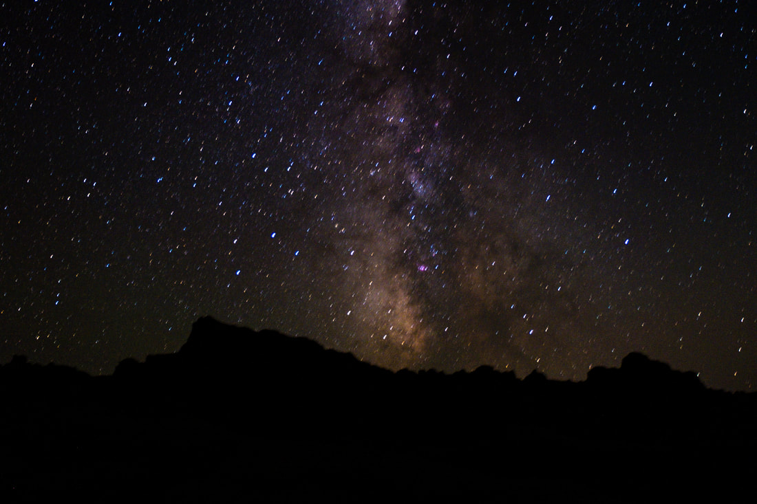 Milky Way - first try - still learning We were on the road by 7:30 and got gas in Custer. We were in Wind Cave National Park by 8:30. We got our cave tour ticket for 10:30. We choose the Natural Cave entrance which was a 1.5 hour tour with 300 steps. It was a great tour, much longer than the Jewel Cave tour. You really felt like you were exploring a cave - but with electric lights. Luckily the 300 steps were only down and there was an elevator up. After the tour we had a picnic lunch. We did the Prairie Nature Trail. It was very different from the trails we have been doing in Custer with trees and rock spires. It was getting very warm by now so we decided not to do another trail. We drove south to Hot Springs. We didn’t do the Hot Springs water park but had a raspberry sorbet at an ice cream shop. We toured the Mammoth Site and saw the ancient fossils. We headed back to Custer and noticed smoke in the distance. There is a wildfire northwest of Rapid City and I-90. It is clear here and no smoke. We were both tired so we decided not to do a sunset. We had a snack supper. We did our normal nightly chores, plus cleaning and icing the Yeti and getting ready to move out tomorrow. We have enjoyed Custer. It is a beautiful place. Unfortunately there is another heat wave and temperatures will be 20 degrees above normal but with 12% humidity for the next 2 days. Miles Today: 114.0 and Total So Far: 3874.0  Boxwork Formations at Wind Cave National Park We left the cabin at 5:30 to get to Slyvan Lake for sunrise. The time for sunrise was 6:54 but it was 7:20 before it came over the canyon wall. We knew the prediction was for clear skies so we didn’t see a lot of color but the reflections during golden hour were beautiful. We headed back to the cabin for breakfast and to get ready for the day. We decided to try the Cathedral Spires hike. We knew that it was steep and 1 mile long. At a half a mile we had to return because the trail became more bolder climbing it was beyond our ability. It was still a beautiful trail. We returned to the cabin by way of the Needles Highway. We had our salad kit lunch again followed by an ice cream treat from the general store here. After some time to rest we drove to Stockard Lake Drive. We were glad we did. Stockard Lake is the biggest lake in the park. We headed back to the cabin and rested a little more before we had supper. We decided quickly to head back to Stockard Lake just in time for sunset. The skies were clear again so there wasn’t a lot of color. We went back to the cabin to do our daily chores - journal writing and planing tomorrow’s drive to Wind Cave - complicated because the Wildlife Loop is closed where we need to go so we will have to backtrack to Custer. Miles Today: 103.7. Total So Far: 3759.9  Cathedral Spires on the Needles Highway, Custer State Park, South Dakota After our long hike yesterday we decided that today would be a scenic driving day. We drove the Needles Highway first. We stopped at Slyvan Lake and thought we would do an easy walk around the lake. We found out that it turned into a hike that needed our trekking poles so we turned around. We did find a good place for sunrise. We drove to Custer to get gas and drinks from the grocery store. We came back to the Visitor’s Center and the State Game Lodge. We thought we would eat at the restaurant here but we found out that it was buffet - not good in COVID times. We talked to the ranger at the Visitors Center and got some information about the road closure and hikes. Unfortunately part of the Wildlife Loop is closed. This will make it a little harder for us because we are on the Wildlife Loop and will have to do some backtracking since the last half of the loop is closed. It will also mean that one of the best overlooks and towers will not be accessible. We headed toward the Legion Lake grill and found out that they were just doing take out and only burgers. We got a burger and ate there at the picnic tables. We stopped back by our cabin, since it was on the way to the wildlife loop and got possible things for supper. We drove on the Wildlife Loop to the closure and then back the way we came since that was our only choice. We decided to drive on the Peter Norbeck Scenic Highway and Iron Mountain Road. We had hoped for a good place for a sunset along the way but were unsuccessful. We had supper in our cabin - tomato soup. We decided that tomorrow would be the best day to do sunrise here and that Monday we would go to Wind Cave. Chores done - getting ready for an early rise tomorrow. Miles Today: 131.0. Total Miles So Far: 3656.2  The Needles Highway Custer State Park South Dakota What a day and an accomplishment. We left the hotel at 8:30 and drove a couple of miles to take a picture of the Crazy Horse Memorial. Then we headed to Slyvan Lake to do the Black Elk Peak Hike. Black Elk Peak is 7,242 feet above sea level. This hike has a 1,000 elevation gain over 4 miles - the entire hike was 8.5 miles. We knew it would be hard, but not as hard as it was. There was a lot of climbing over rocks that slowed us down. It also went up almost level with the peak then went back down to the canyon floor and back up again. Karen did the whole hike but Thomas didn’t do the last half mile. This was the hardest climbing over large rocks. We started at 9:30 and finished at 4:30. We took plenty of water but should have taken a snack. When we finished we headed to our cabin at Blue Bell Lodge. It is an old log cabin made with big logs. It has a kitchenette. We were so tired that we just decided to have one of our TV dinners and not eat at the restaurant. We did our daily chores - filled the ice containers in the Yeti, dumped images to the computer, and wrote in the journal. The cabin does not have wifi. There is wifi at the restaurant but there isn't enough room to sit and it is pretty dark. Tomorrow will be a scenic driving day and give our bodies a change to recover. Miles To Day: 33.6. Total So Far: 3525.1  Black Elk Peak in sight only a half mile away  Lookout Tower at Black Elk Peak It is still a mostly cloudy and cold day. We got on our way at our regular time about 8:30. We drove through Rapid City and Sturgis to Bear Butte State Park. This is really a mountain not a butte but you can see why it is called Bear Butte. This place is very sacred to Lakota people and there were prayer cloths hanging on the trees. We started on the hike to the top of the mountain about a 500 foot climb straight up. We knew we didn't want to go to the top but we went about halfway. Even though cloudy it was still beautiful as you could see for miles over the plain. We drove through the Main Street of Sturgis and were very glad that we were no where close to this place during rally week - even though that was a month ago there were still motorcycles riding through the town. I did take one picture. We decided to tour Rapid City. We found a place in the parking garage downtown. This town has statutes of every president on the street corners downtown. We didn't see all of them - I only found one of the 3 Tennessee presidents, Andrew Jackson. We also found Theodore Roosevelt - who has become my favorite president since I have learned so much about him on this trip. We ate lunch at a Hardees - yes there was one downtown and we could eat outside. We toured the Journey Museum - which was excellent. It is arranged like a journey through time to the tell the story of the Black Hills. When we got there we were the only guests in the museum so we got to choose which movie we saw. We watched the one on the night sky and legends of the Lakota people. After the museum we headed to Walmart to restock. We will be staying in a cabin in Custer State Park so we bought things for all our meals. We have found that those salad kits with dressing and everything, while too expensive for use at home are great when you are living out of your car. Our last stop in Rapid City was the Chapel in the Hills. This is a beautiful Stav church built on the plans of a Norwegian church. This is the second one we have seen on this trip. They are beautiful wooden carved churches. Now we headed to Mount Rushmore. This is the last night that they will do the lightning ceremony of the season. We got there about 2 hours early. We ate our salad meal in the parking lot and then packed up and headed into the monument. Since we visited Rushmore on our road trip in 2017 we didn't do any of the hikes. Instead we just got our places at the amphitheater. We had great seats since it was an hour before the ceremony. At the end of the ceremony they asked for all veterans and active military to come forward for the lowering of the flag. We were on the top tier so Thomas made it all the way down just in time. We drove to Custer in the dark and made it here by 10:00 Miles To Day: 174.6. Miles So Far: 3491.4 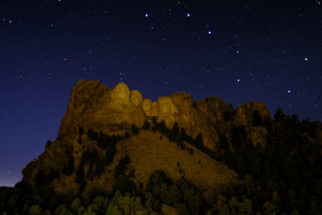 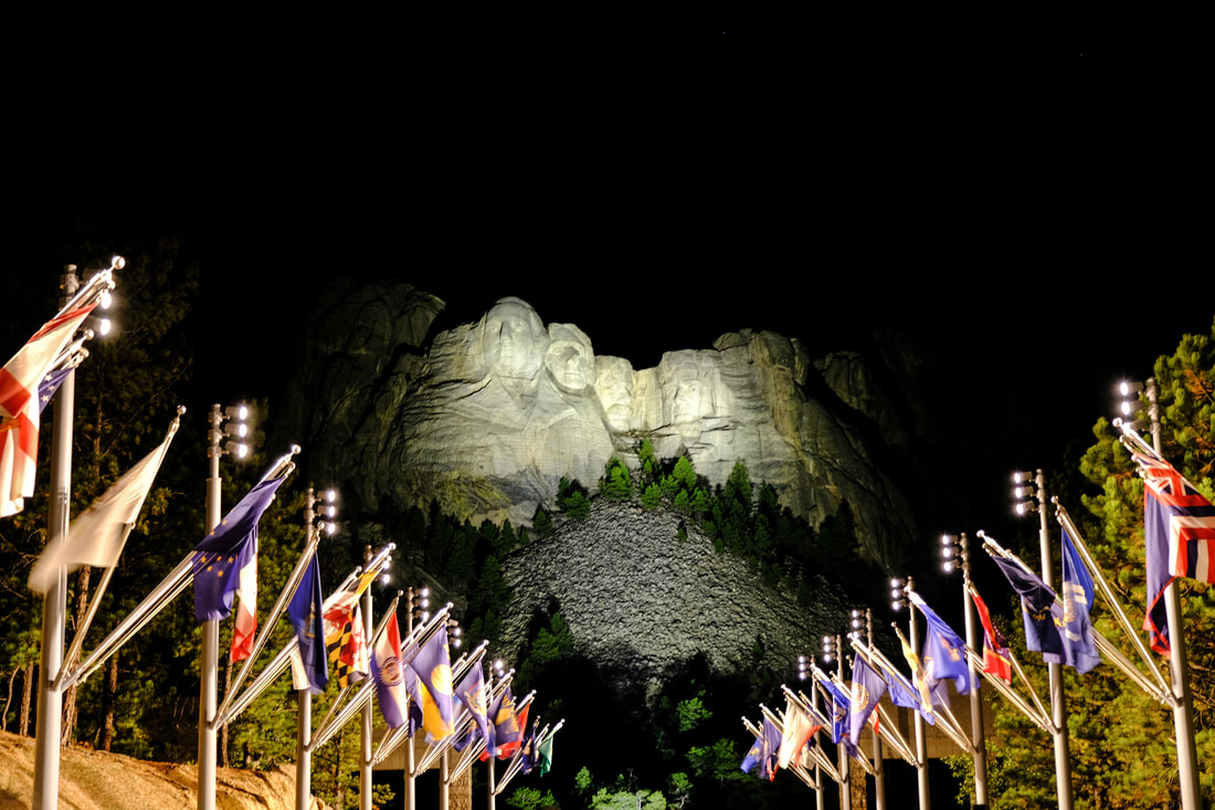 The cold front come in during the night and it was still raining we we got up. We took our time getting ready and packing up. We even watched the TV news. We left the hotel at 9:30 and headed toward Jewel Cave. The drive took us through Wyoming - which means that we have traveled through 8 states: Kentucky, Illinois, Indiana, Iowa, Minnesota, North Dakota, South Dakota, and Wyoming - well 9 if you count Tennessee. We got gas in Newcastle, Wyoming. The cold weather has returned and there was still a light rain or mist most of the day. We made it to Jewel Cave and got a 1:30 cave tour ticket. We had our picnic lunch in the car since it was cold, misty, and windy. Since the elevator at the cave is out of commission we had to do a hike down to a man made entrance and were only able to go through one room. The hike back was pretty steep but even with the rain it wasn't really muddy. We drove on to Custer and checked into our hotel, a old-fashioned one that reminded me of my grandparents hotel in Gatlinburg. It is a very small room but it is enough for us. We ate supper at the Subway across the street. We thought we had plenty of time to relax before bed and would get to bed early - BUT I had a computer error that almost cost me my photo library. It was operator error but we were able to get the external hard drive that I use for my photography open again and then we transferred all the files to my other drive (NOTE TO SELF: always bring at least 2 hard drives in case on fails, maybe even 3). This took 2 hours - images that I take with my camera are huge files and there are a lot of images. Thankfully we got everything working again but it was 10:30 before we got to bed. Miles To Day: 86.6. Total So Far: 3316.8  Formations inside Jewel Cave - you need to enlarge to see that they are like crystal jewels We were ready and had breakfast by 7:00am. Our first trail was the Savoy Nature Trail. It was a really beautiful trail and short, only 2 miles. It was a chilly start but the temperature was rising quickly and also the wind. We drove on the forest road past Roughlock Falls to find the Little Spearfish trail - this was 5 miles on a dirt road. When we got to the end of the road there was no readable trailhead information or trailhead markers. So instead of risking getting lost in the wilderness we decided to head back. We drove back down the canyon and found the 11th Hour Gulch and the light was much better this time. We kept driving and stopped at Victoria Tower butte and then to the Devil's Bathtub trail head. We found out that this trail was mostly walking down a creek so we decided not to take it. We had a splurge lunch today at the Latchstring Restaurant across from the lodge. We at out on the deck and it was truly beautiful. We decided that we would explore the town Spearfish since it was too hot to hike. By now it was 90 degrees. We visited the US National Fish Hatchery with some nice grounds and a little free museum. We came back to the lodge and we did laundry. Thankfully the lodge has a guest laundry that was at the end of our hall so it was easy. I had brought a roll of quarters and we have now used them all. We also ran out of detergent so we threw in a little Dawn to have enough for 2 loads. Since it was now late afternoon and we were only going to have crackers and snacks for supper I decided to try to see if the light was any better on the Savoy Nature Trail since it was only a mile from our hotel. The storm clouds were moving in and I still didn't get what I wanted. But as I was backing out of the parking space I looked up and saw a rainbow. The wind was strong and there were a few raindrops but I waited and watched and pretty soon there was a double rainbow. It was faint but still visible. We are in for the night and getting ready for 30 degree weather tomorrow and a cloudy day. We will go to see Jewel Cave and then on to our next hotel in Custer. Miles Today: 55.6. Total Miles: 3230.2 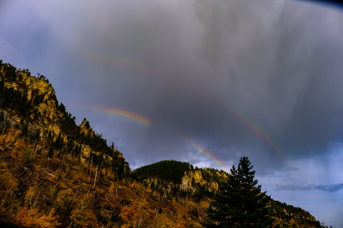 We started the day at 6:35 with a short hike to Spearfish Falls - right across the street from the lodge. Next we drove 1 mile to Roughlock Falls. We came back here for breakfast. We drove down to Bridal Veil Falls - which was only a trickle and without the sign you wouldn't know it was a waterfall. We did a longer 3 mile hike on the Iron Creek Trail. By this time it was 12:30 and getting hot. We came back to the lodge for our microwave lunch. We decided to drive to Deadwood since it was too hot to really hike. This town has a "historic Main Street" like the old west. So if you like to go to saloons and gamble and get drunk then Deadwood is the place for you. Since that is not something we enjoy we did a short walk on the Main Street and headed back toward Spearfish Canyon.We stopped at 11th Hour Gulch pull off. We may try that one tomorrow when light is better. We came back to the lodge for picnic supper and tried one more time for Spearfish Falls but the sky is still just white. Taking pictures here has been frustrating. Since there are no clouds and the heat makes the sky hazy the dynamic range of any image is to great for a camera to capture. It is surely beautiful here. I got back to the room in time to meet with my Sunday school class for the last 10 minutes. It was good to see everyone. As usual, planning our day for tomorrow. Miles Today: 69.3. Total: 3174.5  Iron Creek Trail, Spearfish Canyon We left the hotel at 8:15 and headed to Dikenson for gas and a re-supply at Walmart. The next hotels don't serve breakfast so we needed to stock up on yogurt and Belvita bars. We also got gas. We headed to Gladstone to begin our drive on the Enchanted Highway. This is a 33 mile highway with gigantic sculptures along the way. They were created by a resident of Regent who felt his city was dying and he wanted to bring life to it. It is differently a very interesting drive. We left Regent following Highways 20, 21, and 22. We had decided that it was going to be a long day and we would leave off traveling to Castle Rocks National Landmark since the GPS said another way was shorter. When we got to the shortcut, it was on a dirt road - a long way on a dirt road where the speed limit was 55 mph - don't think so. This turned out to be a good move because it took us right to Castle Rocks - where were beautiful and right off the road. There was also a pit toilet there which was also a blessing since there wasn't going to be a gas station or anywhere else to stop for another 150 miles. We had a picnic lunch there. This was our last stop in North Dakota.
We entered South Dakota and began a very long 3 hour drive on a 2 lane road - straight as an arrow with a speed limit of 65mph. You could literally just see the road for miles ahead with nothing but cattle fields. We got to the marker for the Geographic center of the United States but it was going to be 16 miles on a dirt road so we opted out - it was getting late in the day by this time. We did stop in the closest town, Belle Fourche, South Dakota which hd a nice park with a marker and state flags. We stopped here for gas, a Diary Queen treat, and a car wash (the front of our car and windshield was splattered with bugs). We drove on to Spearfish and then through the Spearfish Canyon Scenic Highway. It was great to see green and gold trees and hear rushing water. We got to the Spearfish Lodge around 5:00. We are still on Mountain Time. We unloaded the car for our 3 night stay here. We did a short walk around the lodge and the beautiful canyon walls with trees. Miles Today: 290.1. Total Miles So Far: 3105.2 We decided that today we would take some time to rest. We have been pushing ourselves pretty hard. We got up at our regular time but we stayed in the room and read our Bibles and had our yogurt breakfast. We drove to the park about 10:00 to see Roosevelt's Maltese Cabin. We drove to the Chateau do Maris, the home of the founder of Medora - the town is named after his wife - the Marquis des Maris. He was a young Frenchman who came to the west to make his fortune in cattle ranching. We didn't tour the home or the exhibits since the price for admission was $10. The lady that was working at the desk must think the price was too high also because she offered to let us watch the video about the place. We drove on up to the Medora Outdoor Musical which closed at Labor Day - it would have been neat to see the show. We got a good view of Medora from up on the hill. We drove back to the motel and walked around in Medora and got a take out pizza. After some more time spent resting - I worked on editing some more images - we left the room at 4:30 for a sunset at Boicourt Trail. It turned out to be a pretty colorful sunset after all. Since we had supper at the trail - Thomas had a piece of pizza that was left - I was still too full to eat - we stayed until dark. Driving back on the scenic loop is a little scary in the dark. We started the job of repacking and filling up the ice in the Yeti for our trip tomorrow. We have enjoyed the Badlands and Prairie but are glad to get to the Black Hills tomorrow. Unfortunately there is a heat wave for the next three days so our wonderful fall weather will be replaced with temps in the high 80's - then it looks like fall weather returns for at least the next 10 days after that. Miles Today: 68.1. Total Miles: 2815.0  Sunset at Boicourt Trail, TRNP We left the motel by 5:30 am for sunrise at the Painted Canyon Overlook and Nature Trail. While the skies were clear and sunrise was mostly just an orange ball, golden hour was beautiful. It was also pretty chilly at 40 degree. I finally got to wear my winter clothes and new socks - this is my favorite temperature. After golden hour we headed back to the motel to get ready for the day. I went to the little grocery store/gas station for some breakfast foods. We headed back to the Painted Canyon to do the nature trail. It had a few challenging places that couldn't have done without our trekking poles. It was pretty neat to go down into the canyon. We only did the inner loop and didn't go all the way to the canyon floor - mostly because the trails are basically buffalo trails that aren't marked that well. We couldn't exactly tell where the loop was supposed to go so we decided to just go back up the trail to the top of the canyon. After our hike we drive into Medora - which is basically closed for the season. We found 3 shops that were open and they had more gifts than souvenirs. We had our soup for lunch and headed back to the park. We decided to drive all the way to the end of the scenic loop and then do the trails we wanted to do on the way back. The trails in the park are either short 1-2 miles or very long - like 10 hours of walking. So we did the short ones. In addition to the Painted Canyon this morning which was a mile, we did the trail to the Old East Entrance. This trail goes through a prairie dog town and they were neat to watch. It was an out and back total of 1 mile. The wind had picked up now and it was blowing 20mph. Hiking in that kind of wind isn't easy. Next trail was the Coal Vein Trail which was a loop trail. It was about 1.5 miles. It also had some challenging ups and downs but was doable with the trekking poles. Next trail was the Buck Hill Trail. This is the second highest point in the park. The highest point is at the Painted Canyon where we were in the morning. It was also a short trail - only about a mile -but it was very steep at the start. Since the sky was completely clear we decided not to stay for sunset and headed back to the motel for supper. We had a sandwich for supper. We are just going to stay in and rest a little. We are not going to do a sunrise tomorrow since the skies are completely clear. Karen walked a little more than 8 miles today. Miles Driven Today: 84.5, Total Miles So Far: 2746.9
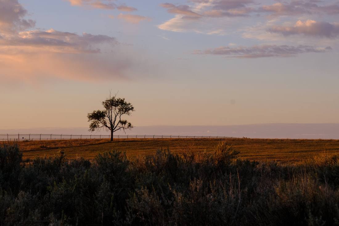 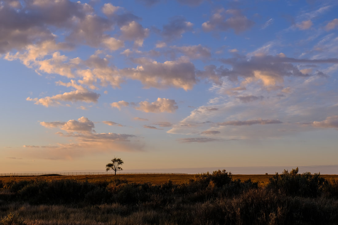 We slept late today and didn't leave the hotel until 8:45. It was a great hotel and good breakfast. We headed to New Town so see Lake Sakakawea, The Three Bears Bridge, and the Three Affiliated Tribes Museum. We also got gas here. We were a little disappointed in the museum as it was rather small and there was now a charge. At the museum the lady told us about a new Interpretive Center down the road. It looked brand new - not even sure they were totally finished. Their Internet wasn't working so you couldn't pay admission but it was also $10/person and we had already paid at the previous museum so we decided to just head on out. Too bad that this Interpretive Center did not show up on any of the web pages or tour books or we would have stopped there instead of the Three Tribes Museum. We headed to Medora on the Killdeer Three Bears Scenic Highway. It was beautiful; however it was a major highway with more big trucks than cars and the speed limit was 65 mph. There were no pull offs or any place to stop so we will just have our memory. We decided not to stop at the Little Missouri State Park since the description made it sound much like TRNP. We got to Medora at 12:30 Mountain Time. We were able to check into our hotel - the Badlands Motel. It is much like the "motor courts" of the past where you park right in front of your room. We found one of the two restaurants open for lunch since much of the town closed at Labor Day. We headed to the park and the visitor's center to check out trails and ranger programs. Unfortunately there are not any of those since they stopped at Labor Day. Also the Medora Theater also stopped preforming on Labor Day. We went back to the hotel to finish unpacking. We drove the complete scenic highway through the park, stopping at several lookouts. We did two short nature walks. The highway used to be a loop but the last several miles washed out and so now you drive to the end and then turn around and go back. We stopped for the second time at Wind Cave for sunset. Unfortunately clouds moved in and there wasn't much color. On the way back we stopped at the only gas station/grocery store in town. You don't want to go below a half a tank in these parts. Miles Today: 228.3. Total Miles So Far: 2662.3  Along the Little Missouri River in TRNP We left the hotel by 6:00am - since they serve breakfast starting at 5:00 we even got breakfast. We got to the park in plenty of time to find our sunrise spot - which was the same as sunset - the river bend overlook. It was 40 degrees, my favorite temperature. The thing about the park is that the same spot looks different at different times of day. We drove all the way to the end of the scenic loop and did a few other stops. We headed back to the motel for lunch at 11. We got carry out from the local BBQ place. It was very good. After resting a little we headed back to the park where we did 3 hikes. There are very few short trails in the park and parking lot to the best one that everyone recommends was closed. We did a short hike on the Buckhorn trail to see the cannon ball formations. We did another short hike on the Little MO Nature Trail. Our last hike was our longest - 2.5 miles to Serpti Point. It was 82 degrees by this time but thankfully since the wind was 15-20mph it didn't feel quite like an 82 degree hike with no shade at home would feel. Since the skies were completely clear again we decided not to try to picnic at the park and wait for sunset. We headed back to the motel and got a milk shake at the Hardees and fixed our supper from our supply in the car. Looking froward to resting some. The sun was so strong today that I even wore the sun hat I bought for the trip - very glad I had it. My face would have been very sun and wind burned without it. Thomas also wore his hat, of course. Tomorrow we move on to Medora and the South Unit of the Theodore Roosevelt National Park. Miles Today: 124.1. Miles So Far: 2434.1 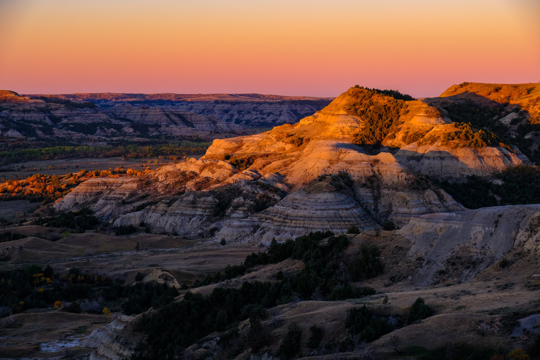 Sunrise at River Bend Overlook, TRNP  Today was another amazing blue sky with white fluffy cloud day. There is such beauty in the sky that sets out before you and makes everything look so small. We drove on the highway 1806 - the Lewis and Clark Scenic Byway for most of the day. We stopped at the Double Ditch State Historic Park. For almost 300 years more than 5,000 people from the Mandan tribe lived at this site along the Missouri River. We enjoyed the Lewis and Clark Interpretive Center and Fort Mandan State Park in Washburn, North Dakota. We explored the Knife River National Historic Site. It was so beautiful here. Our next stop was the Garreston Dam - the longest earthen dam in the US - more than 2 miles long. Still here there wasn't a place for a rest room. And we were very glad that we started the morning with a full tank of gas. The next part of the drive was the hardest - just because it was so long and no place to stop. We made it to Theodore Roosevelt at 5:00, just as the park ranger was closing up. He told us to just put Thomas's pass on the windshield. We drove another 15 miles to Watford City - this is the closest motel to the park. We unpacked in a hurry and headed back to the park for sunset. It was a clear night with no clouds. This such an amazing place - filled with beauty all its own. After sunset we drove back to our hotel and purchased gas. We plan on doing a sunrise tomorrow. Miles Driven Today: 287.7 Total So Far: 2,309.9 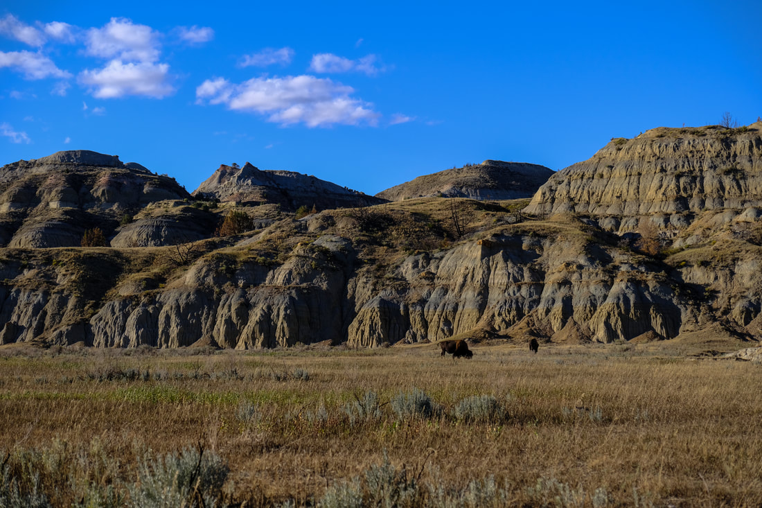 The day started rainy and windy. Since we finished touring Valley City yesterday and it is only a short drive to Bismark, we stayed at the hotel a little longer. We left at 8:45. That was really a nice hotel, glad we were there for 2 days. We got gas and then got on I-94 and headed west. We decided to drive on the interstate since some of the roads that we were going to take that parallel the interstate were not paved and we would have been driving in mud. Our first stop was Jamestown, home of the giant buffalo and a Frontier Town - which was closed. We drove on to Bismark and toured the state capital. This is a very unusual capitol. It is an 18 floor skyscraper. You can see it for miles around as it is taller than any other building. It is build of granite in Art Deco style. We went to the observation tower to see the view. We also toured the North Dakota History and Culture Museum, which we enjoyed very much. We had lunch in the cafe there - there were just 2 other people eating lunch and we were more than 6 feet away. You can see from the picture that the skies turned a beautiful blue and were filled with fluffy clouds. 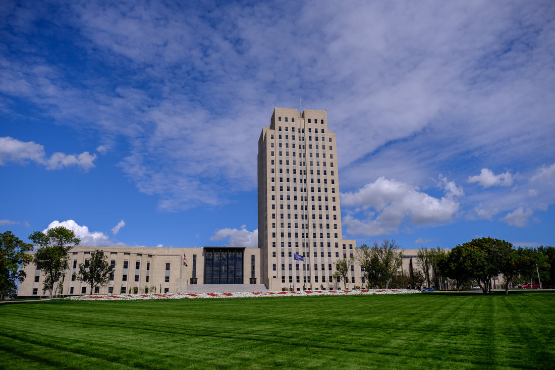 Next stop was Fort Abraham Lincoln - site of a fort and also a Mandan Indian village. There were beautiful views of the rolling hills of the prairie. I am fascinated by the trees - many of which stand alone. Also the fall colors are beginning to show here. This fort is on the Missouri River. After checking into our hotel - about a 20 minute drive - we had sandwiches for supper. We got more bread and soft drinks from the Walmart in sight of our hotel. We headed back to Fort Abraham Lincoln hoping to catch a nice sunset. It was OK but the clouds dropped down and hid the sun. Back to our motel and getting ready for tomorrow's drive to Watford City and Theodore Roosevelt National Park, North Unit. Miles Drive Today: 193.2. Total Miles so far: 2022.2 |
Daily JournalI hope to post something everyday however this may not be possible since we may not have an Internet connection in every place we are staying. Archives
December 2021
Categories |


 RSS Feed